
Filling the remaining gaps
As the accuracy of astronomical observations improved and fainter stars were charted, the opportunities grew for innovators to introduce new constellations even among the area of sky known to the ancient Greeks. Any pretext that constellations should resemble the objects they represented had by now been abandoned; they had become simply named areas of sky.
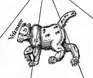
Ten more constellations were introduced in the late 17th century by the Polish astronomer Johannes Hevelius (1611–87), filling the remaining gaps in the northern sky. These were listed in his star catalogue dated 1687 and depicted on his accompanying star atlas called Firmamentum Sobiescianum, both published posthumously in 1690. Hevelius insisted on measuring star positions with the naked eye even though he possessed telescopes for observing the Moon and planets; many of his constellations were deliberately faint as though he was boasting of the power of his eyesight.
Of Hevelius’s inventions, seven are still accepted by astronomers (Table 3). The rejected three were Cerberus, Mons Maenalus, and Triangulum Minus (see Chapter 4).
Lacaille’s southern survey
Although the northern constellations were now complete, there were still gaps in the southern sky. These were filled by the French astronomer Nicolas Louis de Lacaille (1713–62) who sailed to South Africa in 1750. There he set up a small observatory at the Cape of Good Hope (not yet known as Cape Town) under the famous Table Mountain, which impressed him so much that he later named a constellation after it, Mensa. At the Cape from August 1751 to July 1752 Lacaille observed the positions of nearly 10,000 stars, an astounding total in the short time.
On his return to France in 1754, Lacaille presented a map of the southern skies to the French Royal Academy of Sciences which included 14 new constellations of his own invention (see Table 4). An engraved version of the map was published in the Academy’s Mémoires in 1756 and Lacaille’s new constellations were rapidly accepted by other astronomers. Whereas Keyser and de Houtman had mostly named their constellations after exotic animals, Lacaille, being a child of the Enlightenment, commemorated instruments of science and the arts, with the exception of Mensa, named after the Table Mountain under which he had carried out his observations.
THE STAR CATALOGUE AND ATLAS OF JOHANNES HEVELIUS
Johannes Hevelius (1611–87),
compiler of the last major star
catalogue to be made with
naked-eye instruments.
JOHANNES HEVELIUS was a wealthy brewer from Danzig, now Gdańsk, Poland. In the 1640s he set out to enlarge and improve upon the star catalogue of the Danish astronomer Tycho Brahe. Hevelius observed from a platform built over the roofs of three adjacent properties that he owned, using naked-eye instruments such as a quadrant and sextant. He was assisted from 1663 by his second wife, Elizabeth (c.1646/7–c.1693). In 1679 a fire destroyed much of the building and his instruments but his precious catalogue was saved. This, along with his star atlas, was in the process of being printed when Hevelius died in 1687. Elizabeth supervised its final publication in 1690.
Hevelius’s master work came in three parts: an introduction called Prodromus Astronomiae, which included descriptions of new constellations he had invented; the catalogue of 1,564 stars, called Catalogus Stellarum Fixarum, divided into 56 constellations (for a table see here); and the star atlas, Firmamentum Sobiescianum.
Seven of the constellations introduced by Hevelius are still accepted and are listed in Table 3 (above left). Of these, Scutum had already been published in 1684 to honour the King of Poland who had helped Hevelius with rebuilding his observatory after the destructive fire. The remainder had been invented by 1687, the date on the printed catalogue, even though they were not published until 1690. Three additional Hevelius constellations shown on his star charts – Cerberus, Mons Maenalus, and Triangulum Minus – were later dropped by other astronomers.
For a detailed analysis see The Star Catalogue of Hevelius by Frank Verbunt and Robert van Gent, 2010.

His final catalogue, and a revised map with the names of his new constellations in Latin, was published posthumously in 1763 under the title Coelum Australe Stelliferum. In the catalogue, Lacaille divided up the unwieldy constellation Argo Navis, the ship, into the subsections Carina, Puppis, and Vela that astronomers still use as separate constellations. As well as creating 14 new constellations, Lacaille eliminated a pre-existing one – Robur Carolinum, Charles’s Oak, introduced by the Englishman Edmond Halley in 1678 to honour his monarch King Charles II.
All those from Lacaille’s time onwards who gerrymandered the constellations did so without lasting success, but there were plenty of astronomers who tried to leave their mark on the sky. Constellation mania had reached its height by 1801 when the German astronomer Johann Elert Bode (1747–1826) published his immense star atlas, Uranographia, containing over 100 different constellations; but by then astronomers realized that things had gone too far, and during the ensuing century this number was eroded by a process of natural wastage. In 1899 the American historian R. H. Allen summed up the prevailing situation in his book Star Names and Their Meaning: ‘From 80 to 90 constellations may be considered as now more or less acknowledged’.
The final 88
The matter was settled once and for all by astronomy’s newly founded governing body, the International Astronomical Union (IAU). At its first General Assembly in 1922, the IAU officially adopted the list of 88 constellations covering the entire sky that we use today. (For more information on all 88 constellations and how the final choice came to be made see here.)
One serious deficiency remained, though: there were still no generally agreed boundaries to the constellations. Since Bode’s time cartographers had drawn freehand lines snaking between constellation figures, but these were arbitrary and varied from atlas to atlas. On behalf of the IAU a Belgian astronomer, Eugène Joseph Delporte (1882–1955), drew up a definitive list of boundaries for the 88 constellations.
For consistency with the earlier work of the American astronomer Benjamin Apthorp Gould (1824–96), who in 1877 had published boundaries for the southern constellations in his atlas called Uranometria Argentina, Delporte drew his boundaries along lines of right ascension and declination for the year 1875. The boundaries zig-zagged to ensure that all named variable stars remained within the constellations to which they were already assigned. Delporte also modified some of Gould’s boundaries, particularly in places where he had used diagonal lines and curves instead of perpendiculars.
Delporte’s work, approved by the IAU at its meeting in 1928 and published in 1930 in a book called Délimitation Scientifique des Constellations, amounts to an international treaty on the demarcation of the sky, to which astronomers throughout the world have conformed ever since. Constellations are now regarded not as star patterns but as precisely defined areas of sky, rather like countries on Earth. Unlike the map of the Earth, though, the map of the sky is unlikely to change.

NICOLAS LOUIS de LACAILLE
AT THE CAPE
Nicolas Louis de Lacaille (1713–62), surveyor of the southern skies, painted
in 1762, the year of his death, by Anne-Louise Le Jeuneux (17??–94). She had previously painted a large planisphere of the southern sky that presented Lacaille’s
14 new constellations for the first time.
(Observatoire de Paris)
FROM August 1751 to July 1752 Lacaille observed the southern skies from the rear of a house near Table Bay at the Cape of Good Hope, using a telescope of a mere 13.5 mm (half an inch) aperture mounted on a 3-ft quadrant. With this basic equipment he diligently compiled accurate observations of some 9,800 stars between the Tropic of Capricorn and the south celestial pole.
He marked 1,930 naked-eye stars on a large planisphere over 6ft in diameter which he presented to the French Academy of Sciences in 1754; a smaller engraving containing nearly 530 of the brightest stars was published in their Mémoires two years later along with a preliminary catalogue titled Table des ascensions droites et des déclinaisons apparentes des étoiles australes. Lacaille’s planisphere included the 14 new constellations that he invented to accommodate the otherwise unadopted stars he listed (Table 4).
Another innovation was that Lacaille listed his stars in order of right ascension, whereas previous star catalogues had been arranged on a constellation-by-constellation basis. This system was not only more logical but also made sense in the southern hemisphere where there were not as yet any established constellations.
His final catalogue, Coelum Australe Stelliferum, containing 1,942 entries down to 6th magnitude was published posthumously in 1763. It included the same planisphere as before although this time with the constellation names in Latin rather than French and the stars identified with Greek and Roman letters. In both his initial and final catalogues Lacaille divided the stars of Argo Navis into three parts – the keel (Carina), the stern (Puppis), and the sails (Vela) – but his charts still showed it as a single figure.
Incidentally, a catalogue of all Lacaille’s 9,766 stars was finally published in 1847, not in France but by the British Association for the Advancement of Science in England.

Official boundaries to the constellations were fixed in 1930 by a Belgian astronomer, Eugène Delporte, acting on behalf of the International Astronomical Union. Here is his chart for part of the northern sky, including Cassiopeia and Andromeda, from Délimitation Scientifique des Constellations. The constellation boundaries follow circles of right ascension (the equivalent of longitude in the sky) and parallels of declination (the celestial equivalent of latitude). The boundary of Cassiopeia is highlighted in orange. In this new and more scientific depiction of the sky, the old constellation figures have gone for good. (Author’s collection)
© Ian Ridpath. All rights reserved
Table 4:
Fourteen constellations introduced by
Nicolas Louis de Lacaille in 1754
◄ PREVIOUS