|
Johann Bayer’s southern star chart
|
|
|||||||||||
|
|
||||||||||||
 |
|
|||||||||||
|
|
||||||||||||
|
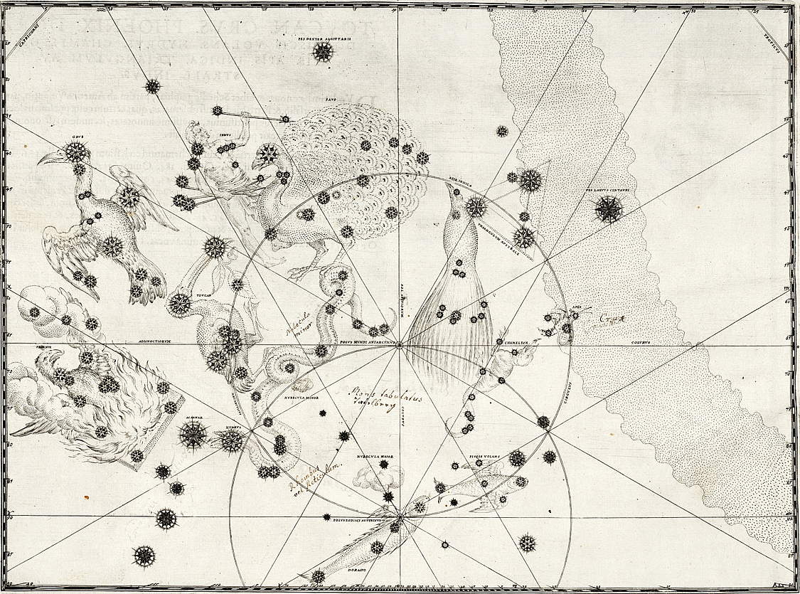
Chart 49 from Johann Bayer’s Uranometria (1603) was the first time that the 12 new constellations around
the south celestial pole appeared in print. This area of sky had previously
been constellation-free because it was too far south for the ancient Greeks to
see. The first reliable observations of the stars in this region were made by
Dutch seafarers at the end of the 16th century. Clockwise from left, the
constellations are: Phoenix, Grus, Tucana (below Grus), Indus, Pavo, Apus,
Triangulum Australe, Musca, Chamaeleon, Volans, and Dorado. Hydrus snakes
across the centre left. Handwritten annotations on the chart were made by a
former owner.
|
|
|||||||||||
|
|
||||||||||||
|
Johann Bayer’s Uranometria atlas of 1603 was not only the first great celestial atlas, it was also the
first to cover the entire sky. What made it so was the inclusion of a special
chart covering the area around the south celestial pole (above). Bayer’s south polar chart depicted the 12 new constellations that had been invented
only a few years earlier from observations made by the navigator Peter
Dirkszoon Keyser and some colleagues on the first Dutch trading expedition to
the East Indies, known as the Eerste Schipvaart.
For European astronomers at the turn of the 17th century, Bayer’s chart of this hitherto invisible area of sky must have been as sensational as
were the first photographs of the far side of the Moon in more recent times.
Uranometria devoted an individual chart to each of the 48 classical Greek constellations
listed by Ptolemy in the Almagest, but Chart 49 differs by lumping all the new Southern Dozen together. This was
reasonable enough, since no catalogue of their component stars had yet been
published.
The observations made on the Eerste Schipvaart had gone directly to the Dutch
cartographer Petrus Plancius in Amsterdam and these stars, divided into the 12
new southern constellations, first appeared on a globe produced jointly by him
and Jodocus Hondius in 1598. Hondius published revised versions of this globe
in 1600 and 1601. The Dutch historian Elly Dekker has demonstrated that Bayer almost
certainly copied the positions of the southern stars from these Hondius globes,
as he had no original observations to work from.
Bayer’s atlas was far more accessible than individually made and expensive globes, so
his Chart 49 would have been the main way that these new constellations were
introduced to a wider public, to the extent that Bayer was sometimes credited
with their invention, which he assuredly was not. (Two decades later another
German, Jacob Bartsch, was similarly credited with inventing constellations that were actually the
work of others.)
At the centre of Bayer’s Chart 49 is the south celestial pole for the year 1600. Lower down is the
south ecliptic pole. Circles of 23.5° radius encompass each pole, while radial lines extend outwards from them at 30
degree intervals. At right is the stippled band of the Milky Way. The two
Magellanic Clouds, termed Nubecula Major and Nubecula Minor, are depicted as
cumulus-type clouds in the lower left quadrant.
Most of the 12 new constellations are concentrated towards the left of the
chart. This is because the effect of precession had moved the south celestial
pole towards Centaurus since ancient Greek times. As a result, the ‘zone of invisibility’ had shifted noticeably since the Almagest was compiled.
In all, 140 stars are plotted on Bayer’s chart of the southern sky. Of these, 121 are gathered into the dozen new
constellations while another five form a southern extension to Eridanus that
ends with the star marked Acarnar, known to us as Achernar. (This southern
extension can also be seen on Bayer’s individual chart of Eridanus, on which he also assigned Greek letters to these stars.) Twelve more stars on
Chart 49 are left unformed, i.e. not part of any constellation. At top centre
and top right are two Ptolemaic stars labelled ‘Pes dexter Sagittarii’ (right foot of Sagittarius) and ‘Pes laevus Centauri’ (left foot of the Centaur), i.e. Beta Sagittarii and Alpha Centauri; these were
presumably included for reference.
Actually, two of the ‘stars’ on Bayer’s chart are not really stars at all: one, in a coil of Hydrus beneath the claw
of Tucana, is the globular cluster we now know as 47 Tucanae; and the other,
between the fin of Dorado and the Large Magellanic Cloud (which Bayer called
Nubecula Major) is 30 Doradus, otherwise known as the Tarantula Nebula.
Bayer’s Chart 49 remained the definitive picture of the south polar skies for the next
century and a half, until the French astronomer Nicolas Louis de Lacaille reshaped some of the Southern Dozen and populated the intervening gaps with 14
more constellations of his own devising in the 1750s.
Unlike the charts for the individual Ptolemaic constellations, Bayer published
no star catalogue to accompany his Chart 49. For a discussion of this chart and
the identities of the stars on it, see my paper here.
|
|
|||||||||||
 |
|
|||||||||||
|
|
||||||||||||
|
High-resolution scans of Chart 49 in Bayer’s Uranometria are available from the US Naval Observatory. Click on an image to
download.
|
|
|||||||||||
|
|
||||||||||||
 |
|
|||||||||||
|
|
||||||||||||
|
|
||||||||||||
|
|
||||||||||||
|
|
|
|
|
|
|
|
|
|
|
|
|
|