
Flamsteed’s Atlas Coelestis
Celestial mapping took another major stride in the 18th century with the work of the first Astronomer Royal of England, John Flamsteed (1646–1719), who catalogued nearly 3,000 stars down to 8th magnitude with unprecedented precision from the newly founded Royal Observatory at Greenwich. Flamsteed’s star catalogue was published posthumously in 1725 in Volume 3 of his Historia Coelestis Britannica; the catalogue section itself was called Catalogus Britannicus. Four years later came Atlas Coelestis, a set of 25 elegantly engraved celestial charts based entirely on Flamsteed’s own observations.[note]
Unlike Bayer and Hevelius, who devoted a chart to each constellation, Flamsteed's atlas was divided into sections of sky featuring more than one constellation, as in modern atlases — see, for example, the tableau of Orion and Taurus below. As a result, some constellations continued onto a second chart. The far southern skies, below the horizon of Greenwich, are covered by one small chart based on the observations made by Edmond Halley at St Helena in 1677–8. This southern chart depicts the 12 constellations of Keyser and de Houtman plus Halley’s own invention, Robur Carolinum, now obsolete.

Orion and Taurus from John Flamsteed's Atlas Coelestis (1729). Orion is shown from the front, facing the bull, as he appears in the sky, whereas Bayer's Uranometria of 1603 had shown him from behind, facing away from the bull. The southern part of Orion appears on Flamsteed's chart of Eridanus and Lepus.
Flamsteed’s stars were divided into 55 constellations. Two Ptolemaic constellations, Ara and Corona Australis, were omitted because they were too far south for him to see. He accepted six of the constellations invented by Hevelius (Canes Venatici, Lacerta, Leo Minor, Lynx, Sextans, and Vulpecula), whereas today’s sky includes a seventh, Scutum; this was reinstated by Johann Bode in his Uranographia of 1801. Flamsteed’s remaining three non-Ptolemaic constellations were Camelopardalis, Coma Berenices, and Monoceros.
In the Atlas Coelestis, Flamsteed took particular care to depict the Greek constellation figures exactly as Ptolemy had described them. The introduction to the atlas contains some disapproving words about the way that Johann Bayer had represented the constellation figures in his Uranometria:
‘Having drawn all his human figures, except Boötes, Andromeda and Virgo, with
their backs towards us, those stars, which all before him place in the right shoulders,
sides, hands, legs or feet, fall in the left, and the contrary ... whereby he renders the
oldest observations false or nonsense.’
Despite popular misconception, Flamsteed did not introduce the so-called Flamsteed number system for identifying the stars in each constellation; that was done in 1783 by the French astronomer Joseph Jérôme de Lalande (1732–1807). In a French edition of Flamsteed’s catalogue Lalande inserted a column in which he numbered the stars consecutively in each constellation in the order that Flamsteed had listed them, and this is the system that astronomers mean when they speak of Flamsteed numbers. Stars are usually referred to by their Flamsteed numbers – for example 61 Cygni or 70 Ophiuchi – only when they are not already identified by a Greek letter.
One legacy of Flamsteed’s atlas that is sometimes overlooked is the sequence of smaller popular atlases that it inspired: Jean-Baptiste Fortin’s Atlas Céleste in France (1776 and 1795), Johann Bode’s Vorstellung der Gestirne in Germany (1782 and 1805), and Alexander Jamieson’s Celestial Atlas in England (1822), all of which in turn had their own imitators. See my page on Antique Star Atlases for more on this Flamsteed tradition.
Bode’s Uranographia
Flamsteed’s catalogue and atlas set new standards in astronomy, and I have used his atlas as one of the sources for illustrations on these pages. The other main source is the greatest of the old-style pictorial star atlases, Uranographia, published in 1801 by the German astronomer Johann Elert Bode (1747–1826), director of Berlin Observatory. It consisted of 20 charts and actually appeared in five parts from 1797 onwards; 1801 was the completion date.[note]
Bode’s Uranographia (or, to give it its full title, Uranographia sive astrorum descriptio viginti tabulis oeneis incisa ex recentissimis et absolutissimis Astronomorum observationibus) was the first atlas to depict virtually all the stars visible to the naked eye (i.e. down to sixth magnitude), plus a fair selection of those down to eighth magnitude (six times fainter). Over 17,000 stars are plotted, taken from the observations of various astronomers including Flamsteed, Lacaille, Lalande, and Bode himself. To accompany the atlas, Bode produced a catalogue called Allgemeine Beschreibung und Nachweisung der Gestirne, also published in 1801.
Uranographia was also the first major star atlas with boundary lines drawn between the constellations, albeit vague and ill-defined, unlike the rigorous modern boundaries. (Bode, incidentally, was not the first to do this – the French cartographer Didier Robert de Vaugondy (1723–86) had preceded him in 1764 – but Bode was the best-known and hence most influential.) Even Flamsteed, normally so punctilious, had been entirely unspecific about the extent of each constellation on his charts.
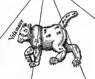
Bode intended the Uranographia to be comprehensive and he certainly succeeded, for in addition to charting a greater number of stars than any previous cartographer he also depicted more constellations – over 100 of them (for a complete list see here). Among them were five constellations making their debut on this atlas: Globus Aerostaticus and Felis, both suggested by Lalande during the preparation of the atlas, while Lochium Funis, Machina Electrica, and Officina Typographica were invented by Bode himself. None of these five survived the test of time. Bode, incidentally, said that he had not intended to introduce any new figures on his atlas until Lalande suggested Globus Aerostaticus to him in 1798; by then he had already reached Chart XV. Hence these five new figures appeared on Chart XVI onwards.
Bode’s Uranographia marked the end of an era. Thereafter, astronomers placed decreasing emphasis on the fanciful (and physically meaningless) constellation figures of the Greeks, concentrating instead on the exact measurement of position, brightness, and physical properties of the stars.
End of a tradition
In the transition from classical to scientific mapping that occurred during the 19th century one atlas stands out: the Uranometria Nova of the German astronomer Friedrich Wilhelm August Argelander (1799–1875) published in 1843. In this the constellation figures, printed in red, were reduced to shadowy insignificance by comparison with the stars. This same two-colour style was followed by Argelander’s countryman Eduard Heis (1806–77) in his Atlas Coelestis Novus of 1872. The southern sky was covered by the Uranometria Argentina atlas of 1877 compiled by the American astronomer Benjamin Apthorp Gould (1824–96). These atlases were the standard references for professional astronomers of the day, and their choice of constellations helped establish the eventual list of 88 adopted by the International Astronomical Union in 1922.
By the end of the 19th century, two thousand years of Greek tradition had finally given way to the facts-and-figures approach of astronomical census-takers and statisticians. Where the ancient Greeks imagined their gods and heroes populating the sky, modern astronomers have discovered the existence of an equally fantastic pantheon of objects with names such as red giants, white dwarfs, pulsars, quasars, and black holes.
PICTURES OF MATCHSTICK MEN
As the use of traditional constellation figures died out in the 19th century, star charts became a confusing mass of dots. To help users pick out the constellation shapes, map makers began to join up the main stars in each figure with lines, giving them a matchstick-like quality.
The first person to do this seems to have been Alexandre Ruelle (1756–18??), an assistant at Paris Observatory in pre-revolutionary France. Extending the growing revolutionary fervour to the sky, Ruelle swept away the conventional constellation shapes of the astronomical ancien régime and substituted a sparer, more proletarian style. He presented his results in 1786 on a chart titled Nouvelle uranographie, consisting of northern and southern hemispheres with an equatorial strip below. In the accompanying booklet he explained his rationale:
‘I thought there could be no simpler and easier way of teaching the knowledge of the sky than to substitute for these fantastic figures triangles, squares, polygons or other geometric figures which really make visible the various groups of stars by supposing the brightest stars of each constellation linked together by lines.’
Ruelle’s approach sounds like an early Cubist deconstruction of the sky.
Although joining up stars in a constellation by lines is a convention now widely encountered on popular charts, Ruelle’s innovation was adopted only gradually. It certainly did not influence Johann Bode just over a decade later when he produced his massive Uranographia, an atlas proudly featuring more of the old-style decorative constellation figures than ever before.
Not surprisingly, it was French cartographers who picked up and extended Ruelle’s idea. A French father-and-son team, Pierre Lapie (1777–1850) and Alexandre Émile Lapie (1800–71), produced a pair of celestial hemispheres with linking lines in 1828 as part of a geographical atlas called Atlas universel de géographie ancienne et moderne that went through several reprints. The lines on their charts, however, were quite different from Ruelle’s and seemed to be more concerned with delineating the extent of each constellation figure rather than its shape.
Ruelle’s original vision was revived by another French astronomy popularizer and cartographer, Charles Dien (1809–70). In 1831 Dien published a chart with considerable similarities to Ruelle’s of nearly half a century earlier. Dien followed this with a full-scale Atlas Céleste of 24 charts incorporating linking lines. Dien’s atlas went through numerous editions into the early 20th century, the later ones being revised and expanded by the well-known French popularizer Camille Flammarion (1842–1925). With the adoption of the linking-line convention by the British astronomy writer Richard Proctor (1837–88) in his popular books such as Half Hours with the Stars (1869) and Easy Star Lessons (1881) its wider acceptance was assured.

Orion with its main stars joined by lines, on the Nouvelle uranographie of Alexandre Ruelle (1786). Other charts link the stars in different ways, as there is no official system.
© Ian Ridpath. All rights reserved
A pirated version of Flamsteed’s unfinished catalogue was published by Edmond Halley in 1712, with accompanying star charts by the London cartographer John Senex some years later.
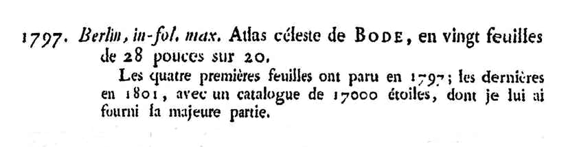
The first four sheets of Bode’s Uranographia were released in 1797, although the atlas was not completed until 1801, as noted in the Bibliographie astronomique by Bode’s French collaborator Joseph Jérôme de Lalande (1732–1807).
◄ PREVIOUS