Edmond Halley’s southern star chart (1678)

Edmond Halley’s southern star chart of 1678 included the 12 southern constellations of Keyser and de Houtman, but with subtle differences from their depictions on Johann Bayer’s chart of 1603. The main differences from Bayer are that Phoenix and Grus face away from each other, and Grus is seen from in front rather than behind; Indus appears to be female; the tail of Pavo is less luxuriant; Apus has a shorter body and longer neck; the snaking path of Hydrus is considerably altered, so that the foot of Tucana no longer rests upon it and the tail is shortened; Chamaeleon has turned so that its feet face away from Apus; and Dorado has become Xiphias, the swordfish, with a long bill. Johannes Hevelius used Halley’s observations for his own chart of the southern constellations published in 1690.
Edmond Halley’s observations of the southern stars from St Helena first appeared in print on this chart of the southern celestial hemisphere issued by John Seller (1632–97), a leading nautical publisher, in July 1678, two months after Halley’s return to England. It was engraved by James[note] Clark (also known as Clerk) (d. 1718), one of Seller’s regular engravers, about whom little is known but who was very possibly the same ‘Mr Clark’ who accompanied Halley to St Helena as his assistant. If so, we can easily imagine them sketching out the chart together on the voyage home.
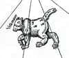
As well as including the southern dozen constellations of Keyser and de Houtman that had been popularized by Johann Bayer in his Uranometria atlas of 1603, the chart gave a debut to Halley’s invention Robur Carolinum, Charles’s Oak, inserted as a tribute to his monarch, King Charles II of England. Patriotically but incongruously, his chart also depicted a red ensign flying from the stern of Argo Navis, and the Cross of St George at the ship’s topmast, as though it were a British merchantman.
The rest of the chart was filled with existing Ptolemaic constellations. (This was still three quarters of a century before Lacaille’s southern survey.) As was usual in Halley’s day, the chart was centred on the ecliptic pole, not the celestial pole, so the constellations of the zodiac are arranged around the rim.
In the top left and right corners are diagrams of the start and finish of the transit of Mercury across the Sun that Halley had observed from St Helena on 1677 October 28. Diagrams at bottom left and right explain the use of spherical triangles for calculating stellar coordinates.
Accurately plotted and attractively engraved, this chart was the first advance in southern-sky mapping since Bayer’s Uranometria three-quarters of a century earlier. It was issued by Seller along with a northern hemisphere chart also engraved by Clark, based on Tycho Brahe’s catalogue, thereby offering all-sky coverage in a pair of sheets each just under 50 cm in diameter. The pair were named The right ascensions and declinations of the principal fixed starrs in both hemisphears to ye year 1678.
Halley’s catalogue of 341 stars was published separately early the following year as Catalogus Stellarum Australium, sive Supplementum catalogi Tychonici (‘Catalogue of the Southern Stars or Supplement to the catalogue of Tycho Brahe’). Johannes Hevelius used Halley’s data for his own chart of the southern constellations in his Firmamentum Sobiescianum atlas published in 1690. Over 40 years after their initial publication, Halley’s observations were used again on the southern half of a pair of celestial hemispheres produced by the London cartographer John Senex (1678–1740).
Image courtesy Bibliothèque nationale de France.
© Ian Ridpath. All rights reserved
◄ Back to Star Tales – Edmond Halley’s southern star catalogue
Sometimes written as ‘Jacobus’, the Latin form of James.

Argo Navis flies a red ensign from its stern and the Cross of St George from its topmast on Edmond Halley’s southern star chart of 1678. These flags were no doubt a tribute to the East India Company whose ships had transported him to and from St Helena to observe the southern sky. Halley’s newly invented constellation Robur Carolinum is at the bottom.