Charting the Chinese sky
Suzhou (= Soochow) planisphere
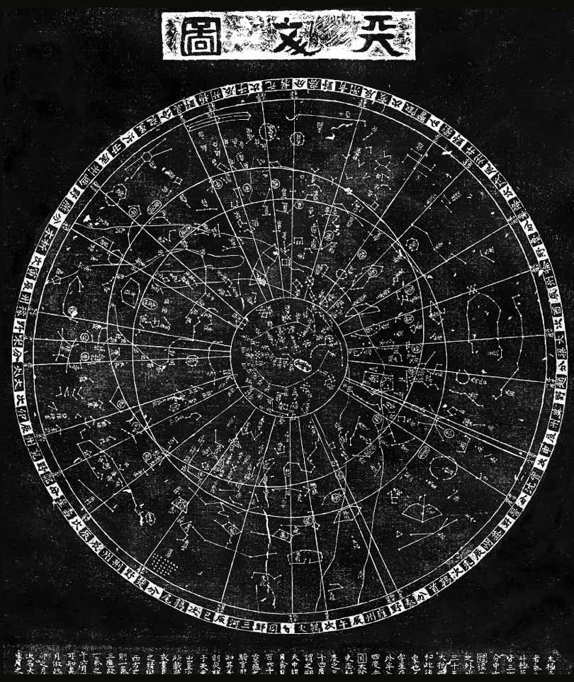
A more complete representation of the Chinese sky than the Dunhuang manuscript is provided by this circular chart from Suzhou, formerly known in the west as Soochow. This chart, just over a metre wide, was engraved on a limestone stele in 1247 but is a copy of an earlier drawing from around 1193. Reproductions of the engraving are taken from an ink-on-paper rubbing, like a brass rubbing; as a result, the stars and lines appear white on a black background. This type of circular chart is usually termed a planisphere.
The Suzhou planisphere depicts the sky from the north celestial pole to about 55° south, indicating that the observations were made from a latitude of about 35° north. Radiating lines, like irregular spokes, demarcate the 28 xiu. These lines extend from the southern horizon (the rim of the chart) to a circle roughly 35° from the north celestial pole; within this circle lie the circumpolar constellations, i.e. those that never set as seen from the latitude of observation. The familiar figure of the Plough can be made out near the lower left of this inner ring, but apart from that there are few similarities between the Chinese star patterns and western ones.
Two intersecting circles represent the celestial equator and ecliptic, which the Chinese called the Red Road and the Yellow Road respectively. An irregular band running across the chart outlines the Milky Way, called the River of Heaven – even the dividing rift through Cygnus can be made out. All 1,464 stars from Chen Zhuo’s catalogue are supposedly included (an inscription on the planisphere tallies the total as 1,565, but this is clearly an ancient Chinese typographical error); not all of the stars show up on the rubbing, however.
For further discussion see The Soochow Astronomical Chart by W. Carl Rufus and Hsing-Chih Tien.
The Suzhou planisphere is a circular representation of the sky centred on the north celestial pole. It was engraved on stone in 1247 and is a near-complete representation of the stars and constellations recognized in China at that time and for some centuries before. An indicator of this map’s antiquity is that the north celestial pole lies over 5° from our present-day pole star, Polaris, because of the effect of precession. When the star positions for the Suzhou chart were observed, in the 11th century AD, the north celestial pole lay in a barren area of sky in the modern constellation Camelopardalis. At that time the closest naked-eye star to the pole was the 5th-magnitude double star we know as Struve 1694 or HR 4893 but termed the Pivot Star by the Chinese; this star was actually at its closest to the pole early in the 9th century AD.
